Frequently Asked Questions

Don't get caught off-guard. Read the FAQs below to know what you need to do to prepare for your trip.

Step 1

Book your trail permit.

APPLY FOR A PERMIT

Step 2

Check your Tides! We will NOT refund you for failure to check if your dates are hikeable. 

TIDE CHART

Step 3

Book your shuttle

BOOK NOW

Step 4

Meet your shuttle at the Black Sands Beach Trailhead, top main parking lot,  in Shelter Cove (Map). PLEASE ARRIVE AT LEAST 15 MINUTES BEFORE YOUR SCHEDULED DEPARTURE TIME.

Step 5

ENJOY!

Leave us a review afterwards!

Share your adventure with us by tagging us on IG @lostcoastadventures

Rules


Where do I meet the shuttle?

The shuttle pick up is at the Black Sands Beach trailhead, top main parking lot, (Google Maps) in Shelter Cove.

If you do not see restrooms and a look out area in the back of the parking lot. You are in the wrong place.

PLEASE ARRIVE AT LEAST 15 MINUTES BEFORE YOUR SCHEDULED DEPARTURE TIME. If you're driving to the meeting place same day, be sure to account for possible traffic (especially from the Bay Area) and construction. Allow plenty of travel time. If says you are 4.5 hours away it is realistically going to take you 5-6 hours.

What is a bear canister?

It helps keep bears away. Bear canisters are containers for your food, scented items like toiletries, and scented garbage. They’re sturdy enough to prevent bears from smelling or stealing your stuff (usually). They are required for all trail hikers.

How many bear canisters do I need?

Each hiker needs 1 bear can, which generally stores 3 days’ worth of food, toiletries, and garbage per hiker. If you’re experienced in traveling light and think you can stash 2 hikers’ worth of scented items in 1 bear canister, feel free to pair up.

Where can I get bear canisters?

See the approved models and links to buy here. You can also rent bear canisters from us for $22/can the entire trip. Please let us know at the time of booking how many you will need.

Note: If you fail to return your canister(s), we will charge $80/each to your credit card on file for replacements.

Where can I get bear canisters?

See the approved models and links to buy here. You can also rent bear canisters from us for $20/can for up to 4 days. Please let us know at the time of booking how many you will need.

Note: If you fail to return your canister(s), we will charge $60/each to your credit card on file for replacements.

Which bear canister(s) do you recommend?

BV500 Bear Vault if you want to share between 2 people. BV450 for individual use

What model of bear canister do you rent?

We have the BV500 and the BV450 bear canisters available for rent.


What half size bear can dimensions?

8.7 x 8.3in

Where do I return my rental bear canister?

210 Wave Drive, Whitethorn, CA 95589. Your driver will go over the drop off procedure when you meet your shuttle.

What kinds of bears are found near the Lost Coast Trail?

Check out this helpful article on California black bears. It notes that you’re statistically more likely to be struck by lightning or eaten by a shark than attacked by a black bear. But don’t tempt them! Get your bear canisters!

Can I bring my dog on the Lost Coast Trail?

Yes, but it’s not much fun for them, and unless your furbaby is a seasoned hiker, it’s not recommended. The hot sand and sharp rocks can rub their paws pads raw, and jumping between boulders can make their nails bleed. There is also depending on the time of year ticks and rattlesnakes out on the trail. Poison oak is another big thing to look out for when taking your fury animals. 

If I do bring my dog, do I need any special gear for them?

Yes, please bring dog boots for them to wear throughout the trip. Dogs must be leashed between Punta Gorda and Sea Lion Gulch due to the large number of seals on the beach. Dogs/seals can be injured or killed, dogs can also scare young seals into the ocean too soon who don't have enough fur yet to survive. There is also an abdunance of deer in this area, there has been numerous times now where dogs will take off to chase them and end up getting lost for days. Leashes also good to have in case your pal is especially frisky early in the day—you don’t want them to wear themselves out.

Is there an extra charge for bringing my dog?

If you book a shuttle ride with your pup we charge a service/cleaning fee of $49.18. We love dogs, but we have to clean very carefully afterwards to accommodate passengers who are allergic to our four-legged friends.

Do I need a permit?

You need 1 permit per group to stay overnight on the trail, but not if you are only hiking for the day (day use). Please note that entry for overnight use is limited:

  • 60 entries per day during the peak season of May 15–Sept. 15
  • 30 entries per day during the non-peak season of Sept. 16–May 14

The new permitting system only gives availabilty for a date 3 months into the future. For example you want a permit for June 20th, then it will not be available on the Rec.gov website until March 20th. And So on and so forth. If you're still confused about how it works you can call the local BLM at (707) 986-5400.

How much is a permit for the Lost Coast trail?

There’s a non-refundable booking fee of $10 per group permit. (New price as of May 1, 2017) 

When and where should I get my permit?

Please book your permit before you book your trip dates. Book your permit here.

Where can I stay overnight near Shelter Cove?

The Inn of the Lost Coast ,and Oceanfront Inn are both located in Shelter Cove and very accessible.

Camping with toilets and showers can be found at our Lost Coast Basecamp and at the Shelter Cove RV Park

You can also camp at Wailaki and Nadelos campgrounds about 15 minutes before you reach Shelter Cove. This camp ground has no showers.

SURVIVAL

Can I call or text on the trail?

Nope. Don’t count on using your phone on the trail or on the way there (except for taking pictures). We’ve heard rumors of Verizon customers getting a bit of reception now and then, but seriously—don’t rely on it.

Can I use a satellite phone?

Yes. You may also bring a Spot or similar GPS-based tracking and communication device.  NOTE: If you are hiking the trail during the high season (May–Sept.) you will generally come across other hikers who may be able to assist you if needed.

Bring cash.

Once you leave Shelter Cove there are no ATMs or other places to get cash. It's a good idea to bring enough for possible emergencies and to leave your driver's a tip to show appreciation for their service. 

Poison Oak

You’ll see poison oak all along the Lost Coast trail. Long pants and closed-toe shoes are advisable to to avoid contact with poison oak (and a severe, painful rash). Remember: “Leaves of three, leave them be.”
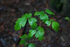
Poison Oak on the Lost Coast Trail

Poison Oak on the Lost Coast Trail

Photo: Malcolm Manners, https://flic.kr/p/9nq1xW
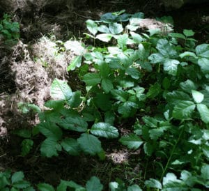
Poison Oak on the Lost Coast Trail

Poison Oak on the Lost Coast Trail

Photo: Tom Brandt, https://flic.kr/p/4VHWvJ

Rattlesnakes

Look out for Northern Pacific rattlesnakes especially when hiking near driftwood, high grass, or brush—you don’t want to surprise one, as they tend to strike when they feel threatened (but will hang back if given space).

What do I do if I'm bitten by a snake?

Never turn your back on the sea.

Make this your mantra throughout your journey. Ocean conditions can change rapidly, and large “sneaker waves” sometimes spring out of a calm sea.

Are sneaker waves all that dangerous?

YES. The steep beaches create a powerful undertow, and rip currents are common. Your odds of survival in the cold water decrease rapidly after 20 minutes.

Ticks and Lyme Disease

Ticks flourish along the trail, and many of them carry and transmit Borrelia burgdorferi, the bacterium responsible for Lyme disease.

What is Lyme Disease?

Lyme disease is a potentially serious illness transmitted by a tick bite. If caught early, it can be successfully treated with antibiotics, but left untreated, the infection can spread to joints, the heart, and the nervous system.

How can I tell if I've been infected?

Early symptoms feel like the flu, and most people will see a bulls-eye rash at the site of the infected bite within 3-30 days (7 days on average). See more about signs and symptoms here.

What should I wear to help avoid tick bites?

Wear light-colored clothing—it’s easier to spot ticks that way. Tuck your shirt into your pants, and tuck your pants into your socks. Wear a hat, too.

Should I use tick repellent? Which one?

It’s a good idea to spray your shoes, socks, belt-line, collar, and hat with tick repellent. Read the Center for Disease Control’s (CDC’s) info on natural tick repellents and pesticides here.

Where and when should I do a tick check?

Check for ticks often: Take a good look at any exposed skin and your clothing, and don’t forget your scalp and behind your ears. Also, when you wake up, check your sleeping bag for ticks that may have bitten and detached from you.

What if I'm bitten by a tick?
  1.  Don’t panic! Antibiotics can often cure Lyme disease if administered within the first few weeks of an infection.
  2. Use tweezers to grasp the tick as close to the skin as possible, or use your fingers protected with tissue paper.
  3. Pull the tick straight out, being very careful not to squeeze or crush it.
  4. Remove any tick mouth parts that break off in the wound.
  5. Wash the wound with generous amounts of soap and water, and apply a mild antiseptic if available.
  6. Stick the tick on tape and bring it to your doctor or local clinic as soon as possible to have it tested.

Why do I need to (yes, need to) check a tide predictions chart?

Red alert: Hiking during high tides can be fatal, even for very experienced hikers.

About 9.5 miles of the trail between Shelter Cove and Mattole Beach is impassable at high tide. High tides occur twice in each 24-hr. period, but they occur at different times every day.

Since there’s no phone reception on the trail, you must check the National Oceanic and Atmospheric Administration (NOAA) tide prediction chart for each day of your trip before you go.

Where do I check the tide predictions chart?

The NOAA chart shows tide information in feet on the left and time on the bottom. You can see how high the tides will be at any given time where the lines intersect. 

Is there fresh water along the trail?

Yes, and most of the freshwater streams are just a few miles apart from each other.

Can I drink water straight from the stream?

NO! Do NOT drink untreated water—it contains pathogens and contaminants you can’t see.

Top tip: Filter extra water at the smaller streams.

In the summer, water from smaller streams tastes a lot better than water from the larger streams (like Flat Creek and Cooskie Creek).

Weather

Most rainfall occurs between October and May. June–September is usually dry and mild, with the occasional storm. Check the 10-day forecast through the NOAA website.

Wind Exposure

The wind can be very strong on the trail. Consider hiking from North to South (from Mattole to Shelter Cove) to keep the wind at your back (there are occasional storms that blow from South to North, but usually the wind blows N-S.)

Be sure to secure your tents firmly when camping; sometimes down-canyon winds up to 60 mph can arise. It’s a good idea to bring sand stakes or otherwise be prepared to weigh down your tent.  

Potential Landslides

Be aware of falling rocks and potential landslides especially after heavy rain

Coastal Environment

Clean your boots.

The Lost Coast has one of the only primordial ecosystems left on the California Coast. Please clean your boots and gear before hiking here. Otherwise you could be spreading plant species from your last backpacking trip.

Bury your poop.

Please bury poop 6-8 inches in the wet sand, below the high tide line. On inland trails, you must bury your waste at least 200 feet from streams, camps, and trails. Learn more about the Leave No Trace 7 Principles here.

Wash dishes in the intertidal zone.

Please only wash dishes and use dish soap 200 feet or more away from streams. You can also do this in the intertidal zone (the area that is above water at low tide and under water at high tide—between tide marks).

How difficult is the terrain?

It’s not for the novice hiker. There are lots of boulders and cobbles to climb over. Very few stretches of packed sand.

Is there a bus or other public transit?

Nope—no public transportation to/from the trail.

We are a very remote community, there is no Uber, Lyft, or Taxi services.

Can I drive to the trail?

Strictly speaking, yes, you can drive two cars and leave one at the trail’s end before you drive to your starting point. BUT: It’s 2 hours of bumpy, windy, unfamiliar roads—not recommended.

Driving on your own is riskier than usual with no public transportation or cell phone reception available in case of an emergency. And remember, at the end, you’ll have to drive 2 hours back to your other vehicle. 

People also have forgotten/lost keys to the second vehicle, leaving them stranded.

Guided Trips

Where do we meet?

Wether you are doing the trail north to south or the other way around we will always meet you in Shelter Cove, CA. 

If you are a group of 6 or more booking a private tour, we can accommodate pick up location if needed.

For trips in other locations that we happen to add, we will specify meeting location.
Are tents provided?

No, tents are not included with the guided trips, if you are in need of a tent please let us know and we can look into providing one for you.

Is food included?

Meals are not included with our economic base price.

You have the option to upgrade to the next tier where meals are purchased, prepped, and cooked for you out on the trail.

We cater to special dietary needs.

No snacks are provided. You must bring your own.

How much extra weight will I carry?

Each person is responsible for carrying their own tent, bear can and a small portion of the food. You can find the weight and dimensions of the Bear Vault 500 above or online. The average weight is about 30 lbs. Food is constantly rotated to keep the guides cans full as yours gets lighter. Whoo Hoo!

What if I don't have all the right personal gear?

We will help guide you towards the proper rentals or purchases. These can be arranged through the REI stores and returned after the trip

How long are the trips?

5 Days, 4 nights. 

For North to south hikes the first night is spent either at the Mattole Beach Campground to get an early start or at our Basecamp. This day is used to make sure everyone makes it, get to know your guide, go over gear and itineraries. Any last minute questions you may have will be answered this night.

4 Days, 3 nights

For South to north hikes. You will meet the day of your starting permit date at the Blacksand's Beach trailhead. Take a few hours to get set up, prepped and debriefed. The first day is a light day. Giving you that evening to set up camp and go over the trips itinerary for the following days.